
|
Jun 06
2013
|
Riverkeeper Report: Summer 2013Posted by Chris in Untagged |
by Chris Trumbauer
Summer is here. Our Honeydipper pumpout boat is patrolling the rivers, our water quality monitoring teams are sampling weekly, and a myriad of sailboats, pleasure craft, commercial watermen, and kayaks can once again be seen daily on the West and Rhode Rivers. It’s a beautiful scene.
As we progress from Spring to Summer, there are always strange weather days – days which seem too hot or too cold for that time of year. Critiquing the weather is an age-old Maryland tradition. However, recent extreme weather, both locally and around the world, have brought discussions of climate change back to the forefront.
Scientists have now announced that we have passed a critical milestone: a concentration of 400ppm of carbon dioxide (CO2) in the atmosphere – an amount never before recorded in human history. The chief sources of CO2 from human activity are burning fossil fuels for electricity (coal, oil) and transportation (gasoline, diesel). High levels of CO2 help trap heat in the atmosphere, and are blamed for rising worldwide temperatures. Scientists warn us that our climate is changing. Why is this bad?
A changing climate will affect our natural resources. Already, in many areas of the Chesapeake Bay, underwater grasses are dying off because of the higher water temperatures. More extreme weather events can mean more stormwater pollution entering our waterways, as heavy storms cause flooding and stream erosion. Our oceans and waterways are becoming more acidic, which affects the natural ecosystem.
Other effects will be seen – and felt. Wildfires are predicted to increase, animal migratory patterns will change, droughts will be more frequent, and even pollen levels will go up.
However, perhaps the most significant potential threat to the West and Rhode River watersheds is sea level rise. Warming temperatures mean accelerated melting of the polar ice caps, resulting in more liquid water in our oceans. The Intergovernmental Panel on Climate Change (IPCC) concluded that after very little change in 2,000 years, sea level rose seven inches in the 20th Century, and is projected to rise as much as two feet during this century. Much of the coastal area in the West and Rhode River watersheds could be flooded if this occurs.
If you think climate change and sea level rise is just banter for environmentalists and college students, think again. Insurers are raising their rates (looked at your flood insurance lately?) and a recent report in the New York Times explains how insurance companies are extremely concerned about climate change but are doing very little to address the problem.
What about us? Will we bury our head in the sand and hope that the harbingers are wrong and that the predictions are overstated? Or will we include climate change in our strategic decisions regarding how we protect, conserve, and restore our natural resources? I love the West and Rhode Rivers and I want them to continue to be among the most beautiful places on the Chesapeake Bay. There are things we can and must do to reduce emissions and "greenhouse gasses." It’s time to take the threat of climate change seriously. Burying your head in the sand usually doesn’t work, especially when the tide starts coming in.
 Many people are unaware that the harvesting of snapping turtles is actively occurring in the waters of the Chesapeake. This is somewhat surprising given the length of the fishery's existence. Archeological evidence suggests the harvest of Snapping Turtles in the Chesapeake region dates as far back as 1000 BC, and it continues to be an in-demand food item throughout the world. While the popularity of turtle based dishes has fallen throughout the United States, it is still a commodity in many countries, most notably China. This international demand makes up a significant portion of sales and is a driving source behind the Chesapeake’s harvest.
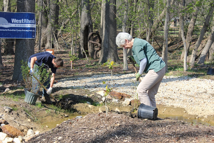 On April 13, we celebrated the completion of our Camp Letts Restoration project with a volunteer tree planting event. Thanks to a grant from the Maryland Urban and Community Forestry Committee we were about to purchase 9 more species of plants to add over 100 additional trees and shrubs to the project. The volunteers were joined by "VIPs" Bob Summers, Secretary of the Maryland Department of the Environment, and Dr. Jana Davis, Executive Director of the Chesapeake Bay Trust. We are very pleased with the project and look forward to seeing it treat water and evolve through the years.

 - April 6th 9am – 12pm

 After 3 years of hard work attaining funding, creating a design and securing permits the treatment wetland at YMCA Camp Letts is finally completed! This January the contractors, EQR, finished building the wetland and planted 150 native trees and shrubs through the project in mid-February. Now the project will capture the sediment and nutrient laden stormwater running off the adjacent horse pasture and treat the water before it reaches Sellman Creek in the Rhode River. We’d like to thank Camp Letts, the Chesapeake Bay Trust, Anne Arundel Soil Conservation District, and the Maryland Department of the Environment for being so helpful throughout the process.
 Utility Right-of-way Stream Restoration in Harwood – Contracted engineering firm, Sustainable Science, has been hard at work surveying and preparing a design for a stream restoration project to take place within a BGE transmission line right-of-way. Funding for the design has been provided by CBT and a Constellation Eco-star grant. The design will include widening the floodplain to slow down water in large storm events, modifying the channel where it is eroding the banks, and creating some wetlands to treat some of the water passing through the site. We should have the design completed by the summer and will then be able to start seeking construction funds. This exciting project has the potential to be used as a model for stream restoration in utility right-of-way areas around the region.


